The old city of Antalya is a rich source of history, with hidden crosses serving as tangible evidence of ancient churches. This walking tour, which delves into the West side of Kaleiçi, near the Yivli Minare Mosque, is a journey of discovery of Christian ruins. Kaleiçi, meaning inside the castle, is the Seljuk fortification that demonstrates various methods of protecting the diverse peoples who once lived within the walls.
A – Upper Port Lookout
The Seljuk conquest of the city took place in 1207, and they renewed the Castle walls in 1216. However, two centuries before this, numerous armies and ancient powers had already left their mark on this crucial Mediterranean Sea port. In light of constant division, the Seljuk rulers divided the castle area between Muslims, Armenians, and Greeks, each for a specific group, with the Port serving as a shared space.
The similarity is still apparent by looking at the maps below. One is from 1905, which shows how the city was divided and today’s city display at the Port lookout. This tour will show some key walls that divide the sections. The in-between section given to the Armenians, but in reality became a shared space with the others. There are limited remains that show Armenian influence in the city, except a church bell at the Toy Museum.[1]https://www.academia.edu/44656658/ Two_Church_Bells_from_Antalya_Traces_of_the_Religious_Soundscape_of_the_Late_Ottoman_Period The 19th and early 20th Century shows that the Muslims and Greeks handled the government and economic affairs evenly.[2]see Evren Dayar’s write up https://akmedmedia.ku.edu.tr/Adalya/Adalya_2023/Dayar_Offprint.pdf So much so that during that time, much of the city was shared peacefully between the two groups.
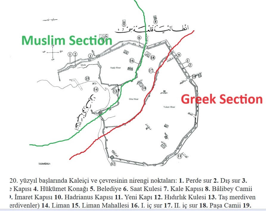
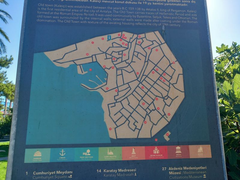
We will journey from the Muslim section to the Greek area to uncover the remains of what I believe was the St. John Byzantine Church. This tour will provide insight into the former Byzantine influence on the city. To access my google map direction of the sites below.
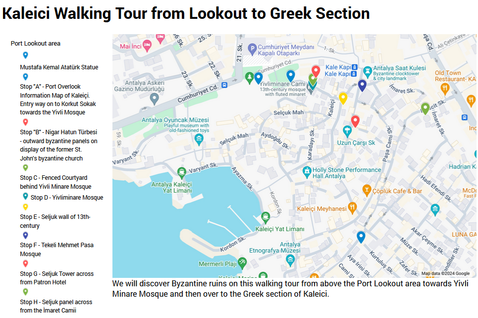
Former St. John Church (Yivli Minaret Mosque)
When the Seljuk conquered a new city, one of their motivations was to promote the spread of Islam. So they set up their Grand Mosques (Ulu Cami) near the city gate and bazaar in the city center.
Their grand mosque called The Yivli Minare Mosque with its fluted minaret, became the center of their community. UNESCO world heritage websites says, “The original mosque was built in 1230 by using the walls of a ruined old church which was exist formerly at the same place.”[3]https://whc.unesco.org/en/tentativelists/6119/ This tour will attempt to reveal some of these ruins.
At this location, in the Seljuks’ spirit, their religion’s domination encompasses the hillside complex. Often tour leaders explain the Islamic display and how the Seljuks conquered the city. However, most likely their explanations do not deal with any details about the former Byzantine site and may not even mentioned that the Apostle Paul left from the Port below (Acts 14:24-26).
So, on this walking tour, we will see a few hidden crosses that give witness to the former church called St. John the Theologian (Aya İoannis Tu Teoloğu).[4]Evren Dayar said: “Cuma Câmii ise Bizans döneminde Aziz İoannis Theologos Kilisesi adındaki bir kilisenin bulunduğu alanda inşa edilmiş.” translated: Friday Mosque is Byzantine in … Continue reading Naming churches after St. John the apostle became a common occurance since he settled and died near to Ephesus.
This complex was the main Seljuk area and the location of their Friday Mosque. We will visit a few key areas in the complex that show evidence of the former church.
B – Nigar Hatun Tomb
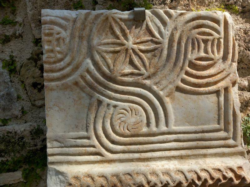
When entering the lower tomb area on the right, a Byzantine panel fragment is down the steps on the left. The marble artwork resembles patterns at the St. John Basilica in Ephesus (Seljuk).
On a recent restoration of the tomb, the wall marble pieces were found, “Spoliated stone [repurposed stones] figures and ornaments from the Byzantine Period were found inside the sarcophagus during the recent restorations. These pieces are currently exhibited on the walls near the tomb.”[5]https://akmed.ku.edu.tr/en/inventory/tomb-of-nigar-hatun/ The tomb, situated near the former church and constructed in the early 16th century, contained or concealed these items within the structure. These symbols were prevalent in numerous churches before the 13th century.[6]Nigar_Hatun_Turbesinden_Bazi_Mimari_Parc-1.pdf
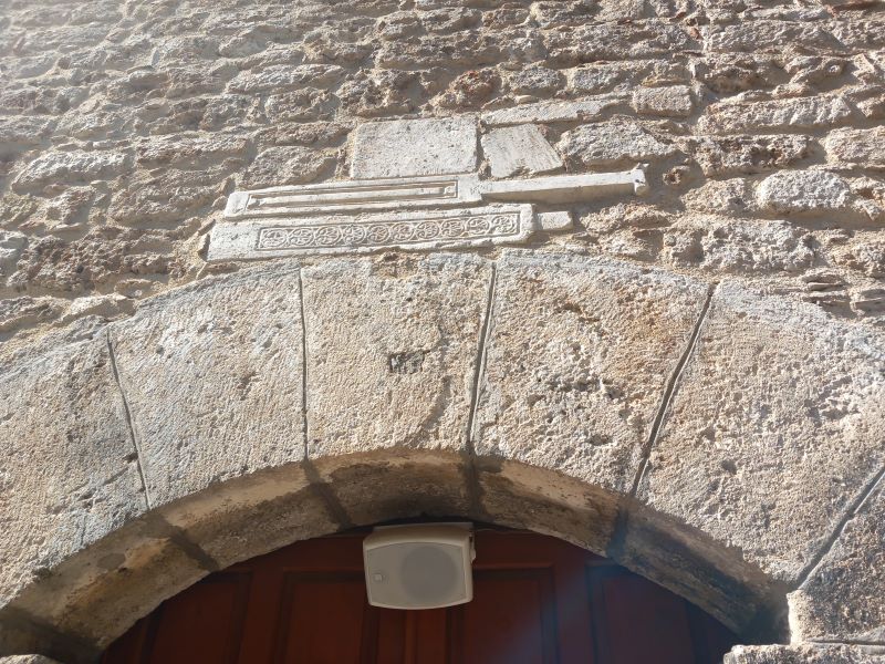
C – Western Upper Courtyard
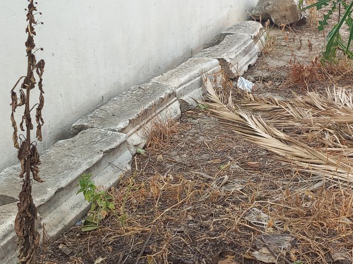
As you exit the Mevlevi Lodge complex, turn left and see an enclosed space near the guard house on the right. The courtyard fencing displays Islamic detail, and along the wall behind the fence, you will find several marble lintels. These lintels were initially used as beams to support doorways and windows in the former church.
Since most Byzantine churches entered from the West, this area possibly displays a built up section, most likely to support the newer building.
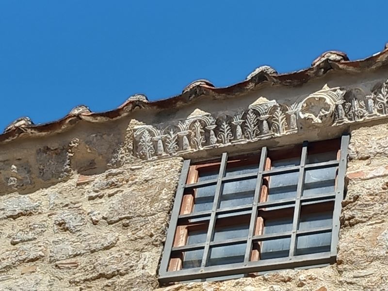
Heading down the steps, take a look at the first window frame on the right (you need to stop on the steps). The above edging displays a beautiful marble templon from the former church. Some of these may have bridged the main door or windows like this. You will notice other marble pieces lining the right wall along the lane towards the mosque’s entrance.
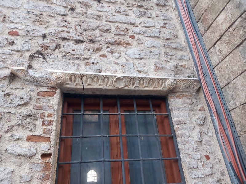
D- Yivli Mosque
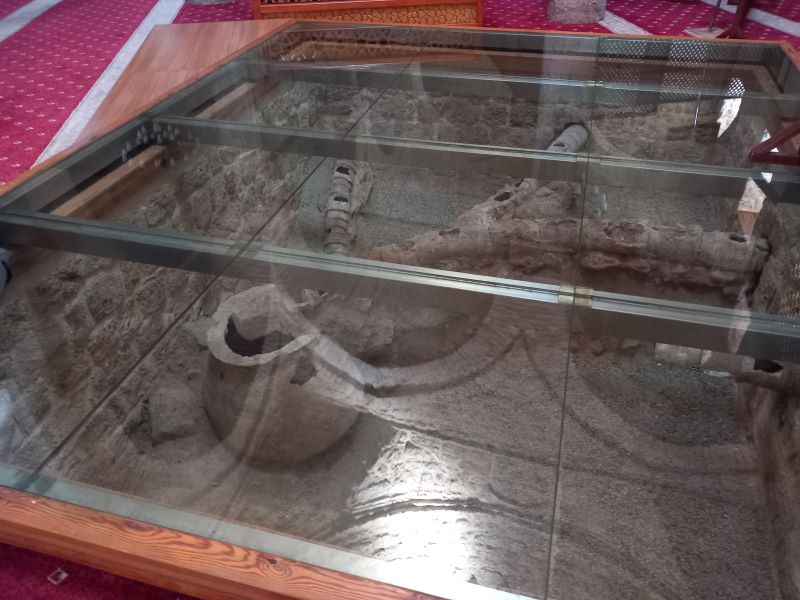
This mosque is the second building on the site after the church, but it sits aligned similarly to the southeast, like the Hagia Sophia. The Byzantine apse was most likely eliminated when the second mosque was built. Within the mosque, two main things stand out. Firstly, there are 12 former pillars of the church. Secondly, there is a water storage unit under the glass area, which some believe to be an ancient heating system. Many Byzantine churches had wells or water sources within the building for religious purposes, and this storage system seems to indicate water coming from the hillside direction.
The upper section near the roof displays a few marble carvings from the former church. The entrances also give evidence of other panels of the church. The carvings showcase either a cross or an image set in marble, some of which have been damaged.
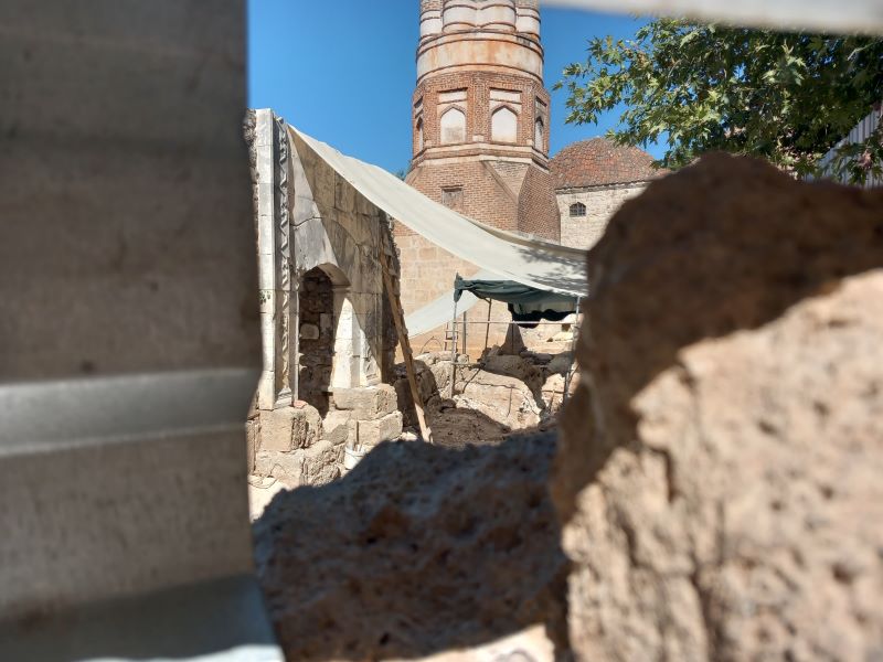
Some historians question why the fluted minaret is so far from the mosque. Did the Eastern side previously show an apse construction, and then the newer mosque changed this but kept the minaret in its place? Or was the minaret more of a centerpiece for the Seljuk complex? Hopefully, after renovation, more details will come about.[7]July, 2024 picture of renovation near the Fluted Minaret
Archaeologists have unearthed 40 graves in the enclosed area east of the Mosque, most likely from the Seljuk period. Various photos show the many walls and remains.[8]https://www.milliyet.com.tr/galeri/antalyada-40-mezar-bulundu-kazdikca-cikiyor-6215521/6


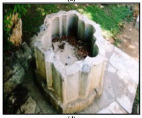
Also not found on the walk but most likely stored within an enclosed area of the Madrasa across the street appears a marble basin that looks very similar to the Byzantine baptism chambers found in the Istanbul Archeology Museum.[9]Antalya’daki Selçuklu Dönemi yapılarında bahçe mekânının analizi Analysis of the gardens from Seljuk period in Antalya Buket ŞENOĞLU, Veli ORTAÇEŞME Akdeniz Üniversitesi, Ziraat … Continue reading With a former Byzantine church at this location, finding this pool does not surprise the researcher.
E – Dividing Seljuk Historic Wall
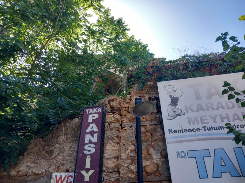
A wall divides the former Muslim and Armenian sections which is near the Taka Butik Otel. The upper supposed Armenian section became a mixed section in which Muslims and Greeks lived in. The wall parallels the upper road called Uzun Çarşı Sokak (the long bazaar street). This street goes from the old bazaar to the Port’s upper walls.
Why did the Seljuks divide the city (Kaleiçi)? In 1212 non-Muslims during Friday prayers took over the city. A Turkish historian, Kubilay Bal said, “Due to the horrific incident in 1212, the gates were closed every Friday until the end of Friday prayers until 1922.”[10]https://www.academia.edu/49345779/History_of_Antalya For 700 years the 22 gates between these sections were closed as a means of protection.
This Armenian section became a shared section in which both Greek and Muslim communities lived.[11]possibly some Armenians merchants lived in this area during the 13th century. Also, I read that the Armenians helped the Seljuks when they invaded parts of northern Syria in the late 11th century so … Continue reading From this wall, walk up hill (left), unless one wants to walk down to the first entrance gate on the left. This will take one to the upper street area onto Uzun Çarşı Sokak.
F – Mehmet Pasha Mosque
The northern courtyard of the mosque hosts Byzantine mosaics beneath the glassed sections. The mosque, sometimes called Tekeli Mehmet Pasha, the early 1600s. “It has been suggested that the building was changed into its present condition in the 17th century by an overall renovation of another that previously stood there.”[12]Antalya-ekeli Mehmet Paşa Camii ve
Tarihlendirilmesi. Leyla YILMAZ, ADALYA IV, 1999-2000, page 306.
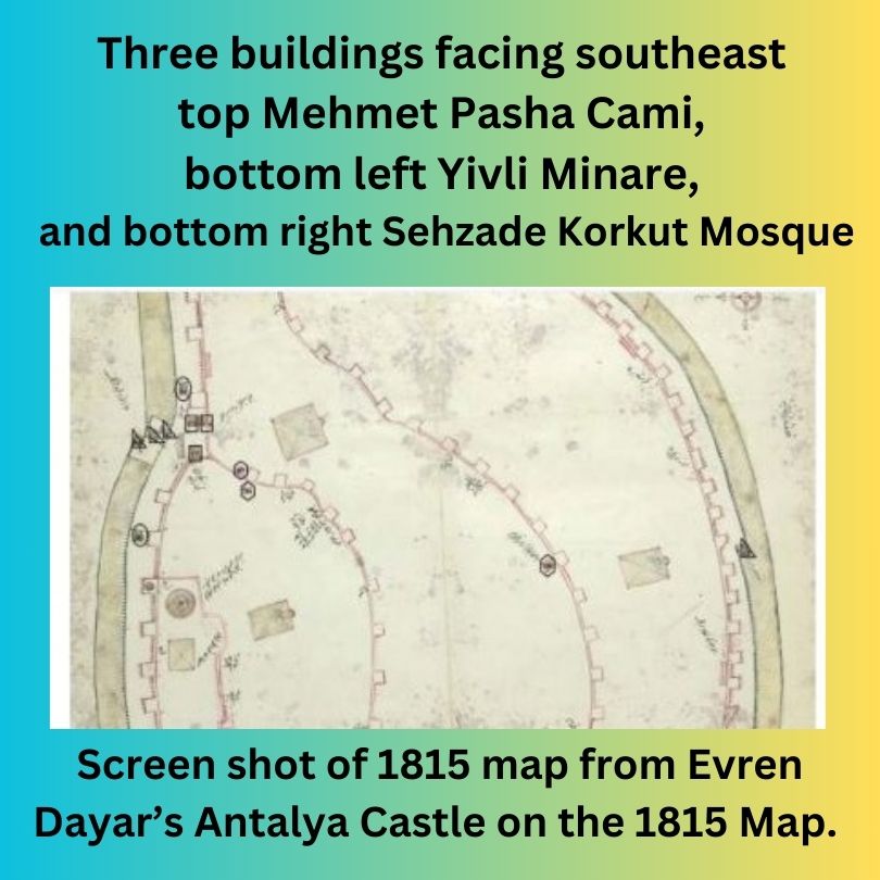
On the 1815 map, three buildings face southeast, such as the Hagia Sophia, one of which is the Mehmet Pasha Mosque. The Byzantine mosaics on the north side of the building make this a significant Byzantine location.[13]1815 Haritası’nda Antalya Kalesi: Surlar, Kapılar ve Burçlar, BELLETEN, Ağustos 2020, Cilt 84 – Sayı 300, s. 667-716
The 1850 renovation likely removed the apse displayed on the 1815 map above.
G – Patron Butik Hotel Tower
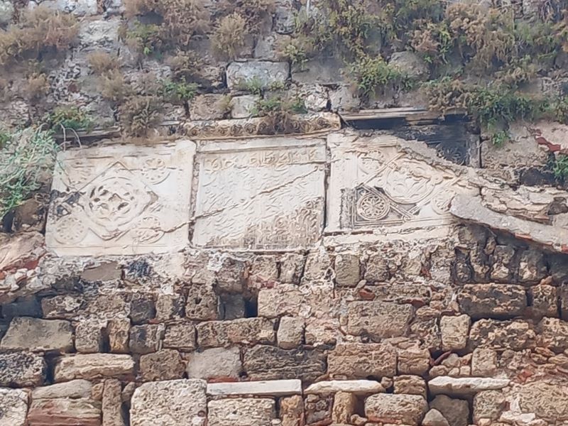
On Uzun Çarşı Street, just north of the Patron Butik Hotel, a tower remains from the 13th-century wall. Arabic in the middle but Byzantine symbols including crosses on the edges. Most likely these were cross panels from the St. John’s Byzantine church. The Seljuks wanted the people to remember their victory over this Christian site.
H on Map – Imaret Tower
Near the Imaret Mosque this tower hosts another Seljuk victory panel. I give a video tour of it on Youtube.
Mescit Sokak Wall with Cross Entry Stone
On one of my first visits to this beautiful city, I noticed this wall had what I called an ecumenical dimension. Then I did not know much about the history and thought it strange for crosses to jet out near to Arabic writings. However, this panel displays into the Greek section and Scott Redford said, that each panel “provides an Arabic language, 13th century official document that concerns the suppression of the only known revolt of an Anatolian city against the Seljuks.”[14]Scott Redford, A NEWLY READ INSCRIPTION ON THE WALLS OF ANTALYA, TURKEY. https://www.jstor.org/stable/27811119 For dramatic affect the Seljuks took parts of the conquerored-church building like St. John and made these panels part of their proclamation. They did not want another revolt so each of these panels face into the non-Muslim sections as victory panels.
From here, you can check out my Greek section walking tour or see about another Byzantine church only a block from where this tour ends.
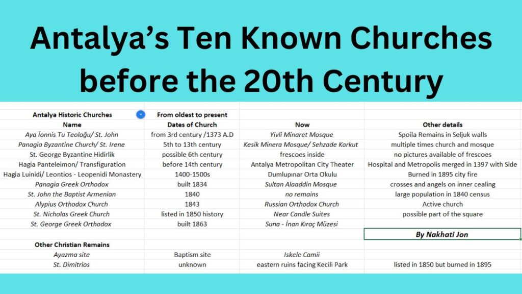
If you have any historical insights to these musings, please let me know. I will continue to update these new findings when possible.
I love to explore the differences, and my book Absurdity of God’s Oneness is a critical difference between Islam and the Bible – both sides do not see it the same way.
References
| ↑1 | https://www.academia.edu/44656658/ Two_Church_Bells_from_Antalya_Traces_of_the_Religious_Soundscape_of_the_Late_Ottoman_Period |
|---|---|
| ↑2 | see Evren Dayar’s write up https://akmedmedia.ku.edu.tr/Adalya/Adalya_2023/Dayar_Offprint.pdf |
| ↑3 | https://whc.unesco.org/en/tentativelists/6119/ |
| ↑4 | Evren Dayar said: “Cuma Câmii ise Bizans döneminde Aziz İoannis Theologos Kilisesi adındaki bir kilisenin bulunduğu alanda inşa edilmiş.” translated: Friday Mosque is Byzantine in the area where a church called St. John Theologos Church was located during the period built.” He references: Pechlivanidis, age., s. 11. found in Antalya Kaleiçi Panhagia Kilisesi ve Câmi-i Cedid. |
| ↑5 | https://akmed.ku.edu.tr/en/inventory/tomb-of-nigar-hatun/ |
| ↑6 | Nigar_Hatun_Turbesinden_Bazi_Mimari_Parc-1.pdf |
| ↑7 | July, 2024 picture of renovation near the Fluted Minaret |
| ↑8 | https://www.milliyet.com.tr/galeri/antalyada-40-mezar-bulundu-kazdikca-cikiyor-6215521/6 |
| ↑9 | Antalya’daki Selçuklu Dönemi yapılarında bahçe mekânının analizi Analysis of the gardens from Seljuk period in Antalya Buket ŞENOĞLU, Veli ORTAÇEŞME Akdeniz Üniversitesi, Ziraat Fakültesi |
| ↑10 | https://www.academia.edu/49345779/History_of_Antalya |
| ↑11 | possibly some Armenians merchants lived in this area during the 13th century. Also, I read that the Armenians helped the Seljuks when they invaded parts of northern Syria in the late 11th century so maybe they were allies of the Seljuks in some regions. |
| ↑12 | Antalya-ekeli Mehmet Paşa Camii ve Tarihlendirilmesi. Leyla YILMAZ, ADALYA IV, 1999-2000, page 306. |
| ↑13 | 1815 Haritası’nda Antalya Kalesi: Surlar, Kapılar ve Burçlar, BELLETEN, Ağustos 2020, Cilt 84 – Sayı 300, s. 667-716 |
| ↑14 | Scott Redford, A NEWLY READ INSCRIPTION ON THE WALLS OF ANTALYA, TURKEY. https://www.jstor.org/stable/27811119 |
I have never heard of this town before but it looks super interesting and historic. From what I understand there are many ancient Roman sites but it seems like they haven’t been highlighted enough.